
|
Home DH-Debate 6. End of Pleistocene |
If you want to know what the climate was like in the Holocene, simply take some outerwear and go out into nature and look around. Holocene refers namely to the present since the end of the Weichsel glaciation.
The interglacial Holocene has supported the development and growth of human civilizations, it has been the cradle of civilizations, not to say their uterus. It started around 11,700 years before present with a sudden warming from the cold period called Younger Dryas. In only ten years time the temperature in Greenland rose with an impressive 8 degrees, which corresponds to that North
Europe's climate was replaced with a Mediterranean climate. It is not known, what caused this rapid rise in temperature.
|
|
Cenozoic is the period of the mammals, which followed the Mesozoic that was the period of dinosaurs. Tertiary is that part of Cenozoic, where no humans
existed , and Quaternary means the part of Cenozoic, where humans exist. Quaternary is composed of Pleistocene and Holocene. Pleistocene is the period that we in common language call the Ice Age. Holocene represents the
present, which basically is a Pleistocene interglacial period. Holocene is represented by the thin red line on the far left. The climate of the Holocene is the subject of this Article.
During the following one thousand years, the temperature increased so that climate became several degrees warmer than today. About 8,000 years before present, in Hunter Stone Age, occurred the hottest period throughout the Holocene. This initiated the warm period called the Holocene Optimum, which lasted almost until about 4,500 years before present, whereafter the temperature continued to drop through bronze age, iron age and historical time until it reached a low point in "The Little Ice Age" in the years 1600- 1700. Within the last few hundred years, the temperature has again increased, but not to such heights as in Hunter Stone Age.
|
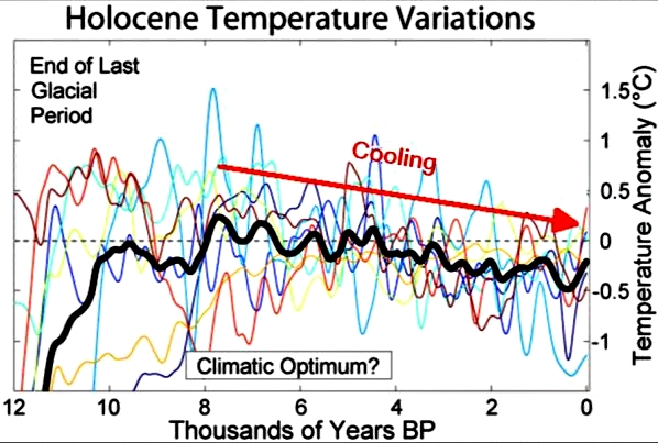
This graph is taken from
Wikipedia. It shows eight different reconstructions of Holocene temperature. The thick black line is the average of these. Time progresses from left to right.
On this graph the Stone Age is shown only about one degree warmer than present day, but most sources mention that Scandinavian Stone Age was about 2-3 degrees warmer than the present; this need not to be mutually excluding statements, because the curve reconstructs the entire Earth's temperature, and on higher latitudes the temperature variations were greater than about
equator.
Some reconstructions show a vertical dramatic increase in temperature around the year 2000, but it seems not reasonable to the author, since that kind of graphs cannot possibly show temperature in specific years, it must
necessarily be smoothed by a kind of mathematical rolling average, perhaps with periods of hundred years, and then a high temperature in a single year, for example, 2004 will be much less visible.
The trend seems to be that Holocene's highest temperature was reached in the
Hunter Stone Age about 8,000 years before present, thereafter the temperature has generally been steadily falling, however, superimposed by many cold and warm periods, including the modern warm period.
However, generally speaking, the Holocene represents an amazing stable climate, where the cooling through the period has been limited to a few degrees.
The general decline in temperatures since 8000 years before present was
overlaid by several cold and warm periods. Thus we speak of five to seven cold periods in Holocene, including the Little Ice Age and several warm periods, including the Minoan, Roman, Medieval and Modern Warm Periods.
|
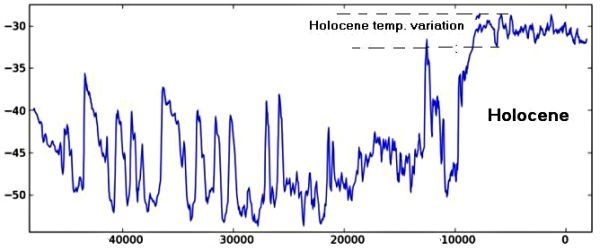
Temperature variations in the Holocene compared with the previous Weichsel ice age based on analysis of Greenland ice cores. The vertical scale on the left shows the temperature on the surface of the ice, and the horizontal scale is years before present. Time progresses from left to right. It appears that the climate of the Holocene really has been very stable and the temperature has only varied a few degrees - The most dramatic event so far has been the 8,200 cold period and the ensuing Holocene maximum in the Stone Age. By contrast, the climate in the previous ice age was not nearly as stable. The temperature often varied more than 20 degrees during a few hundred years or perhaps less.
The Holocene cold and warm periods, however, represent only small
temperature changes compared to both the glaciation periods and the other
interglacial periods.
This unique climatic stability made the development of agriculture possible, it created the basis for the development of civilizations and enabled eventually
the industrial revolution and consequently the modern world with its
technique and myriads of people. Had we not had a window of about 10,000
years of stable climate with only small temperature variations, civilization would not have been nearly as developed, if at all existent, and Earth's
population would have been only a fraction of the current.
|
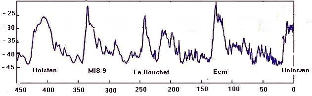
Temperature variations in Holocene compared with the preceding interglacials - The vertical scale shows the temperature on the ice surface, and the
horizontal time scale is in thousands of years before present. It can be seen the Holocene temperature graph has a different shape than the previous interglacial periods. Holocene has a nearly flat top, which represents a fairly stable climate through ten thousand years, while the preceding interglacials are generally pointed, that is the temperature has risen to a maximum and then declined again, maybe after only a few hundred years. Only Holocene could offer a stable climate for a long time, during which agriculture and civilization could develop.
Note moreover almost all heating periods characteristic shape. The heat
comes suddenly, perhaps in a few decades and then decreases slowly. This is also the case for the Holocene, except that temperature has dropped much slower than in the other interglacials and warming periods.
Many believe that the declining Milankovitch insolation explains the
general cooling trend during the Holocene. The Milankovitch insolation is the theoretical insolation (received energy from the Sun) at 65 degrees northern latitude in June. Its variation in the Holocene is mainly due to changes in the axis tilt, such that the northern hemisphere, in the beginning, received a big June insolation, as it turned more directly against the sun during the summer, while the axis in the present is more upright, and therefore the northern hemisphere receives not so much solar radiation in summertime.
|
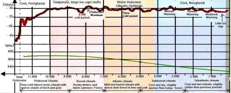
Temperature and Milankovitch insolation during Holocene.
The upper reddish graph represents the temperature in Celsius on the ice
surface in Greenland. The curve is generally falling through the Holocene but overlaid by many cold and hot periods. Many operate with six cold spells, of which the best known are the 8,200 cold period and the Little
Ice Age. The most famous hot periods are the Minoan, the Roman and the Medieval warm periods.
The Norwegian Axel Blytt and the Swede Rutger Sernander developed in the 1800's the Blytt-Sernander period breakdown of the Holocene climate based on studies of Danish peat bogs. It includes the periods Preboreal, Boreal, Atlantic, Subboreal and Subatlantic that are shown at the bottom of the figure. Preboreal is also known as the Birch-pine period. There are many different opinions about when the various Blytt-Sernander periods begin and end.
Today, some believe that this classification is outdated and prefer other
divisions, which includes the Holocene Climatic Optimum, Postglacial and
Neoglacial that all are shown at the top of this figure in colors.
The yellow-green graph shown below the temperature curve represents the theoretical Milankovitch insolation in Holocene in Watts per m2. - The Milankovitch insolation is solar radiation on 65. northern latitude in the month of June. It can be seen that insolation-maximum occurred about 10,000 years before present with about 470 W/m2, and since then insolation has been declining steadily down to today's low value that is slightly less than 430 W/m2.
In the very early Holocene, northern Europe became vegetated by an open and light
birch forest mixed with aspen, willow, mountain ash and pine. The ever milder climate caused average summer temperatures to rise to 18-20 degrees, while winter temperature stood at just below freezing. The composition of the forest trees changed; pine pushed back birch; hazel, elm, oak, ash, alder, fir and linden immigrated.
About 8,200 years ago, there was a sharp cooling in the Northern hemisphere. It has been attributed to an excessive supply of cold glacial meltwater
from glaciers in the Hudson Bay area. Data from Disko Bay show that here too
was a large production of melt water. Samples taken from the ocean floor at
Spitsbergen indicate that here the Arctic waters pushed further south
already 8,800 years ago.
|
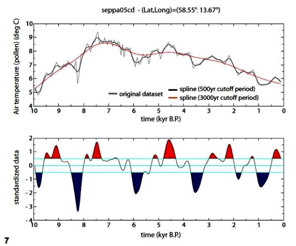
From HOCLAT - A web-based Holocene Climate Atlas (see link below).
Reconstructed summer air temperature from pollen analysis of sediments from the bottom of a Swedish lake at 58.55 northern latitude and 13.67 eastern
longitude, which is a small Swedish lake between Vanern and Vattern.
The original data is the very thin line in the diagram at the top. It has been smoothed with a form of mathematical rolling average over 500 years, it is the blue line. In addition, the original data also have been mathematically smoothed over 3,000 years, it is the red line. The figure at the bottom shows how much the blue line deviates from the red line, which is a measure of climate change. The blue areas thus show how much the temperature of a cold period deviates from the more average temperature in this age, and the red areas show how much the temperature of a warming period exceeds the more average temperature in this age.
It is seen that the 8,200 cold spell represents a very severe climate change. It has been a
sudden change for Stone Age hunters. Moreover, it looks as if the cold periods come at regular intervals. The cold Period 5.900 years before present took place at the transition from Hunter-Stone Age to the Peasant Stone Age. The cold period 3,500 was the beginning of the Bronze Age. The small cold period around 1,800 occurred a few hundred years after birth of Christ, perhaps it was at that time, the Goths left the island of Skanza (Scandinavia). The Little Ice Age seems to come somewhat early.
Many explain the 8,200 cold period as a result of a large discharge of cold meltwater into the Atlantic from Lake Agassiz at the edge of the Laurentide ice sheet in North America.
It may seem paradoxical that a warmer weather in the Arctic, which caused the melting of ice caps and sea ice and thus the production of cold fresh water, caused a colder climate in Northern Europe and probably also in North America. This is explained by that the large amounts of cold fresh water, that is lighter than salt water, disturbed the ocean currents,
and a weakened Gulf Stream was the cause of colder weather along the North Atlantic coasts. Many believe that such meltwater mechanism also caused
The Younger Dryas cold period.
Analysis of oxygen isotopes in stalagmites from Costa Rica shows a dry period around 8,200 before present. From "Tropical response to the 8200 yr B.P. cold event? --" by Matthew S. Lachniet with others.
Even more beyond comprehension is it that a team of American geologists from
the University of Buffalo and other universities have found that during the
cold period glaciers on Baffin Island increased. One can only conclude
that if there simultaneously was produced meltwater, precipitation must have been even very big in the region.
Analyses of oxygen isotopes in stalagmites from caves in Costa Rica have shown that there was a dry period about 8,200 years before present, caused by weaker monsoon and reduced precipitation in Central America. It questions the melt-water Gulf Stream theory, as the climate in Costa Rica's is not dependent of a warm Gulf Stream, this region belongs indeed the area near the equator, which supplies the heat to the Gulf Stream.
The cold period cannot, however, be detected in the Southern Hemisphere, neither in drill cores from the ice sheet in Antarctica glaciers in Bolivia or in samples taken from the seabed off the mouth of Murray River in Australia. This indicates that the cold period can have been a truly North Atlantic phenomenon, perhaps caused by variations in the sea currents.
But after a while, the sea currents in the North Atlantic found back to their old routes if that had been the cause, and about 8,000 years before present began the warmest period of the Holocene ever.
In sediments from the bottom of the lakes, Huelmo and Mascardi, in the Andes Mountains in respectively Chile and Argentina scientists have found evidence of a cold period on the Southern Hemisphere, which lasted 800 years and occurred between 11,400 and 10,200 years before present.

The parasitic plant mistletoe on a willow tree - During the Holocene optimum
parasitic plant mistletoe was widely found in southern Scandinavia. Today it grows further south, in southern England, Central and Southern Europe.
The hottest time in the Holocene occurred in the Stone Age about 8,000 years
before present, it is called the Holocene Maximum. This warm climate continued largely through 3,500 years until 4,500 before present, when it was Neolithic period in Northern Europe.
It is assumed that the average temperature was 2-3 degrees higher than today. This is supported by the fact that plants such as mistletoe and the subtropical aquatic plant Trapa natans grew widespread in south Scandinavia. Linden, elm, spruce and oak were the most common trees in northern Europe's dense forests, which closed the continent's interior into a big impenetrable forest.
In Denmark, scientists have studied Stone Age settlements from the Holocene Climatic Optimum's period and found bones of various terrestrial and marine animals, including swordfish, sturgeon, sardine and tuna, dalmatian pelican and pond turtle, all of which are species that today live in warmer climes.
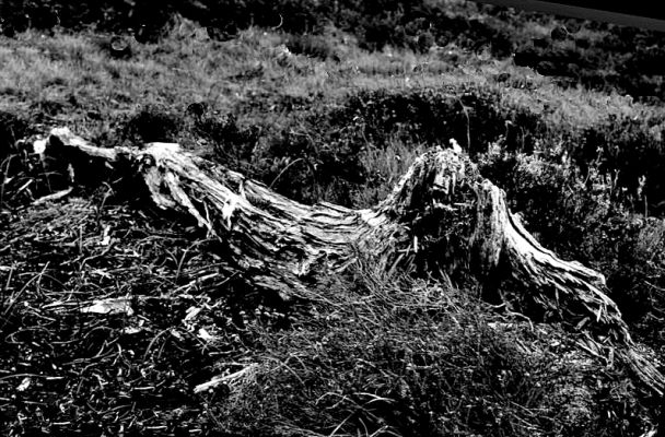
Pine stub in Cairngorm Mountains that is 4,000 to 4,500-year-old.
In Cairngorm Mountains in central Scotland, you can find stubs of 4,000 - 4,500 old pine trees, which grew 650 meter above sea level. This altitude is slightly above the limit for dwarf trees and stunted trees today.
Another testimony of warmer climate in the past can be found in Dartmoor in
Southern England, though slightly later than the Holocene Optimum. Here Bronze Age farmers cultivated the land in 450 meters above sea level, which should be compared with the absolute limit on agriculture today, that is an altitude of 300
meters.
A team of scientists from the University of Copenhagen have analyzed driftwood and beach ridges along the coast of north-eastern Greenland and thereby uncovered the extension of sea ice during the Holocene Optimum.
Driftwood, that end up on the coast of northeastern Greenland come from
North America and Siberia. It has used several years to complete its journey and would only reach the coast of Greenland , if it is encased in ice, since free driftwood will sink to the bottom during such a long journey.
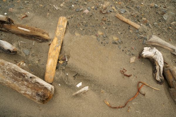
Driftwood on the beach of Spitsbergen.
By collecting and dating driftwood with the carbon-14 method, researchers could calculate the amount of sea ice in different time periods.
Svend Funder and his colleagues also examined beach ridges along the coast. Today beach ridges are not formed along the coast of Northern Greenland, as
sea ice shields the coast year round. By the carbon 14 method, the beach ridges have been determined to originate from the Holocene Optimum, during which period the sea must have been ice-free, at least in the summertime.
It was concluded that sea ice reached a minimum between 8,500 and 6,000 years ago, when the limit for full-year sea ice was located 1.000 km further north than in the present, and in summertime it covered an area only half as large as the sea ice area in the summer of 2007, when sea ice in recent times had its minimum.
Some studies indicate that the sea surface temperature of the world's oceans was up to 5 degrees higher than today's surface temperature (Darby, 2001).
|
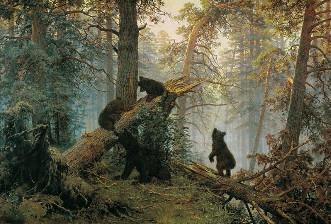
Painting by Ivan Shishkin and Konstantin Savitsky - Throughout most of the first part of Holocene, most of Europe, Asia and North America was covered by forest. A large part of the biosphere's carbon was tied up in the wood of the trees. Agriculture was introduced and as the trees rotted away or were burned, the atmospheric concentration of carbon increased in the form of CO2.
The ice cap in Peary Land in northern Greenland was drilled in 1977. The ice core contained distinct refrozen meltwater layers all way down to the bedrock, which indicates that it did not contain ice from the Weichsel glaciation. That is to say that the world's northernmost ice sheet melted completely away during the Holocene Optimum and was only restored when the climate became colder about 4,500 years ago.
Since less water was bound at the poles as inland ice than nowadays, the World Sea surface level at that time was 3 meters above today's sea surface level.
At the end of Maglemose hunters' period, around 8,500 before present, the
climate in northern Europe had evolved into a so-called Atlantic climate. It
was a mild and humid coastal climate with summer temperatures 2-3 degrees higher than today.
As sea surface level in the World Ocean rose, it caused the salty seawater to enter the Ancylus Lake (Baltic Sea), and the water in the Baltic Sea
basin again became salt. The new sea is called the Littorina Sea after the saltwater snail Littorina littorea. It lasted several hundred years before the salt content reached its maximum.

|
As the kilometers-thick Scandinavian ice sheet began to melt, it formed the
freshwater lake, the Baltic Ice Lake. It was a cold sea with drifting
icebergs. The lake surface was higher than the sea surface of the World's oceans. Some believe that the ice-lake was emptied by a major flood disaster around year 9,600 BC, but most believe that it happened gradually.
The landscape of northern Europe was dominated by icy cold steppes and regular tundra roamed by a small number of reindeer hunters.
After the lake made connected with the World Sea, it became a brackish sea called the Yoldia sea, named after the mussel Yoldia arctica. The Yoldia Sea had connection with the world's oceans through a strait that was located where the Swedish lakes and the Gota river are today.
In the early hunter-Stone Age the tundra became vegetated of a birch forest mixed with aspen, willow, mountain ash and pine.
When Scandinavia was freed from the weight of the huge masses of ice, the land lifted, and the uplift cut off the Yoldia Sea's connection with the world's oceans, and it became once again a fresh water lake called the Ancylus Lake after the freshwater snail Ancylus fluviatilis. Ancylus Lake maybe had drain through central Sweden at the Great Lakes.
As the climate became milder, and the summer average temperature rose to 18-20 degrees, and winter temperatures rarely fall below freezing, also the composition of the forest trees changed, pine replaced birch and hazel, elm, oak, ash, alder, fir and linden became common.
Around 7,000 before present, the climate of northern Europe was a so-called Atlantic climate. It was a mild and humid coastal climate with summer temperatures 2-3 degrees higher than today. The water level in the world's oceans increased after some time making the salty sea water enter the
Ancylus Lake, and the water in the Baltic Sea basin again became salt. The new sea is called the Littorina Sea after the saltwater snail Littorina littorea.
Because of land uplift the Littorina Sea's connection to the World Ocean during the past 2,000 years had become increasingly narrower and shallower, making it to the brackish sea, that we know today as the Baltic Sea.
In Australia scientists have analyzed sediments in the seabed off the mouth of the river Murray and found that from 17,000 to 13,500 years before present the Australian climate was wetter than it is in the present. There have with certainty been found no indications of dry periods either in the Younger Dryas or 8,200 years before present, indicating that these cold periods are phenomena limited to the northern hemisphere.
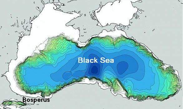
The partially dried up Black Sea around 5,500 before present.
Samples of bottom sediments in the Australian Lake Frome and Lake Woods
show that the climate in early Holocene between 9,500 and 8,000 years ago, and again 7,000 to 4,200 years ago, was considerably wetter than in the present. The beginning of modern climatic conditions in Australia with periodic rainy seasons took place about 4,000 years ago.
Analyses of sediments from the Cariaco Basin in Venezuela indicates that the amount of water discharged into the basin during the Holocene Optimum was much greater than today, indicating that precipitation in the area must have been much larger in the first half of the Holocene than it is today. (Uriarte, Haug).
One of the geographical events in Europe, that most brings our thoughts to the Biblical account of the Flood, is perhaps the sudden flooding of the partially dried up Black Sea, which took place 5,500 years before present.
For reasons, we can only guess, the inland sea had lost its connection to the world's oceans and was partially dried out. Its sea surface lay 150 m under the sea surface of the World Sea. The Black Sea is fed by many large and water-rich rivers, just think of the Danube, Dnester, Dneieper and Don. It is difficult to understand that it may have lost more water by evaporation than it received from the rivers. It must be evidence that it really has been very hot during the Holocene Optimum. It is assumed that the temperature during this period was 2-3 degrees higher than in present.
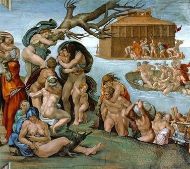
Detail of the motif The Flood by Michelangelo from the Sistine Chapel.
A marginal increase in the sea surface of the world's ocean 5,500 years before present created a small crack in the barrier of the Bosphorus, a negligible trickle of seawater into the Black Sea basin quickly evolved into a huge waterfall of salt water 200 times greater than Niagara. It is assumed that the sea water gushed into the half dried up Black Sea and got sea surface level to rise by 15 cm. a day, and thus raised the water level the 150 meters up to the World Ocean surface level during about three years.
When the flood occurred, there was Neolithic time in Northern Europe and this there had surely been a long time in the area around the Black Sea. The oceanographer Robert Ballard has examined the Black Sea bottom using an underwater robot and found evidence of human habitation.
Many peoples have the story of an initial flood among their old myths. In the Genesis of the Bible God separated the waters and created Heaven and Earth. The Bible has the story about the flood, and how Noah and his family survived. In the Egyptian creation myth was in the beginning also a chaos of water, and the god Ra separated the waters and created the world. In the Scandinavian mythology, the gods Odin, Vile, and Ve killed the original giant Ymer, in the flood that was created by Hrymer's blood all his children, the rimturses, drowned except for Bergelmer and his wife, and by these were the Jotuns. Even the Australian Aborigines have an initial flood among their old myths.
|
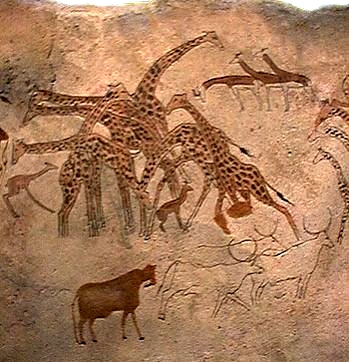
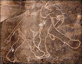
Left: Rock Painting with giraffes from Tassili in southern Algeria.
Right: Rock Painting with an elephant from Tadrart Acacus in Libya.
During a longer period of time, that roughly corresponds to the Holocene Optimum, Northern Africa experienced a time of a considerably more wet and rainy climate than that, which now prevails in the region. Many states the period to be 8,500 to 3,500 BC (10,500 to 5,500 years before present), but the dating seems to be uncertain.
Where now is barren and scorched desert, was then savannah with widespread
grassland and some trees. There lived lions elephants, giraffes and other
animals that are now characteristic of southern Africa.
The former professor of African history at London University Roland Oliver described the landscape as follows: "The major mountain ranges Tibesti and Hoggar, which today are bare rocks, were then covered with forests of oak and walnut, linden, alder and elm. The lower slopes, along with the smaller mountains - Tassili and Acacus to the north, Ennedi and Air to the south - were covered with olive, juniper and Aleppo pine. Through the grasslands of the valleys' rivers were flowing teeming with fish."
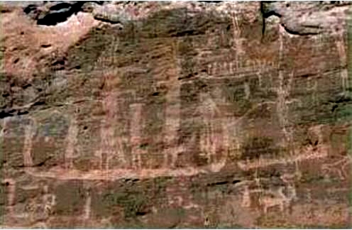
Rock Painting depicting men in boats from Tassili-n-Ajjer in southern
Algeria.
Rock Art all over Sahara recalls a time when the country was greener and
home to lions, elephants, giraffes, antelopes, hippos and crocodiles. A picture from Tassili, which today is a scorched desert, shows men, who stand in boats sailing on water. This shows that there existed lakes and rivers in places, where today cannot be found a straw of grass.
Most rock paintings in the Sahara are found in Algeria, Libya, Morocco and Niger, and to a lesser extent in Egypt, Sudan, Tunisia and some Sahel countries. The Air Mountains in Niger, the Tassili-n-Ajjer plateau in southeastern Algeria and the Fezzan region in southwestern Libya are particularly rich in old rock paintings.
Lake Chad reached a maximum extent of about 400,000 square kilometers,
which is larger than the modern Caspian Sea, with a surface level about 30 meters higher than in modern times.
|
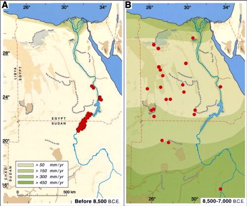
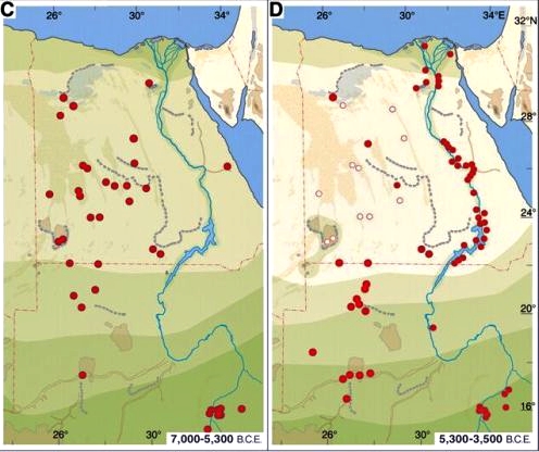
Climate-related settlements in the eastern Sahara through the major phases of the Holocene. Red dots indicate main resettlement areas, white dots indicate more isolated settlements in climatic refuge locations and cyclical shifts of pastures. Precipitation zones are indicated by green nuances in the light of best estimates based on geological, archaeological and archaeo-
botanical data.
(A) During last Glacial Maximum and late Pleistocene, that is 20,000 to 8,500 BC (22,000 to 10,500 years before present) the Sahara desert was devoid of any settlement outside the Nile Valley, and the desert stretched 400 km. farther south, than it does today.
(B) With the sudden onset of monsoon rain around 8,500 BC, the hyper-arid desert was replaced by savannah-like landscapes, which quickly became inhabited by prehistoric people. In the early Holocene optimum southern Sahara and the Nile Valley were apparently too humid and dangerous for
appreciably human settlement.
(C) Around 7,000 BC human settlements have been well established throughout eastern Sahara, where they created a cattle-nomadic culture.
(D) Decreasing monsoon rain caused a beginning drying out of the Egyptian part of the Sahara around 5,300 BC. The prehistoric people were forced to seek into the Nile Valley, settling in oases or to emigrate to the Sudanese Sahara, where rainfall and surface water was still sufficient. Sahara's return to actual desert conditions about 3,500 BC coincided with the initial stages of Egyptian civilization in the Nile Valley. - Kuper and Kropelin (2006).
Around 3500 BC the desert again spread across North Africa, and the scattered cattle nomads moved to the Nile Valley, where they began tilling the soil, and where they created the first Dynasty and thus founded the famous Egyptian culture.
|
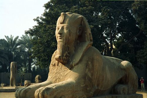
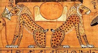
Left: Sphinx from Luxor - A sphinx is a lion with a human head.
Right: Lions that represent the god Aker
In pharaonic times, there were still lions in Egypt. They lived on the border of the desert, where they were known as the keepers of the eastern and western horizon or guardians of the eastern and western descent to the underworld. Sphinxes may depict a pharaoh as a lion figure with a human head.
There lived elephants in North Africa long after the desert had returned
in the central Sahara.
North African forest elephants were somewhat smaller than both the Indian elephant and the African steppe elephant. Its Latin name sounds Loxodonta
Africana Pharaoensis, and it was exterminated in the second century; reportedly many have been killed in the Roman arenas.
It puzzled Cicero that when twenty elephants, an unprecedented number, were attacked by spearmen in the arena, their trumpeting of distress so harrowed the spectators that everyone in the theater began to weep. The show was given by the great man Pompey.
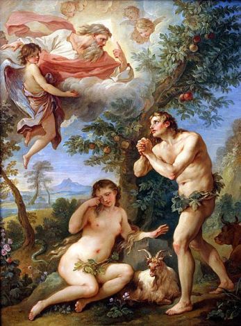
The expulsion from The Garden of Eden painted by Natoire in the year 1740.
Also, the Arabian desert in the Middle East and the Rajasthan desert between India and Pakistan experienced a wet period in the first part of Holocene. In the dry out lakes of the deserts have been found spores from plants, which are characteristic of a savannah vegetation.
Other studies indicate that Central Asia in the early Holocene experienced a wetter climate than today, while summer temperatures, that was from 2 to 3.5 degrees higher than today, prevailed. In China rice could be planted almost a full month earlier than it usually is the case today. Bamboo groves could be found three latitudes farther north than they are found in modern times. (Uriarte, Chu Ko-chen)
Many peoples have old myths about an original homeland, which they left in
the distant past. The ancient Doric Greeks immigrated from the north, the
Scandinavian peoples remember Asgaard and Midgaard, according to their ancient myths the Romans originally came from Troy, and probably the best-known myth of this kind is the Biblical story of the expulsion from the Garden of Eden. It is quite likely that the factors, which forced the peoples to emigrate, have been associated with such climate changes that took place in connection with the end of the Holocene Optimum.
Around 5,500 to 5,000 years before present occurred the Piora cold period, which is named after the Val Piora valley in Switzerland, which was the first place, where it was identified by using pollen analysis. The more heat-loving trees as elm and linden became rarer and never again regained their dominant position in the woods. There have been found indications of this cold period in both Alaska, the Andes in Colombia and in the mountains of Kenya (Lamb).
|
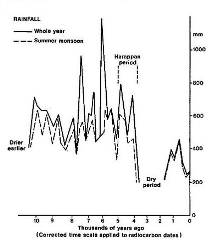
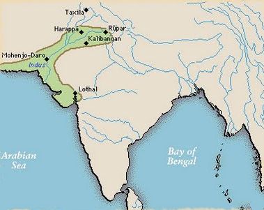
Left: Precipitation in the Rajasthani desert. It is seen that in the period before the Holocene it was a fairly dry desert, the precipitation peaked around 6,000 years before present, and while Harappan culture existed the rainfall was 600 to 800 mm per year. This can be compared to the average annual precipitation in Denmark, which is 745 mm. (Fra H. H. Lamb: Climate, History and the Modern World).
Right: The cities of Harappa and Mohenjodaro existed in the Indus valley 4,000 years ago.
In the Indus Valley, where today Rajastan's arid Thar desert is spreading, the cities of Harappa and Mohenjodaro flourished between 4,600 and 3,900 years before present. When their civilization was at its peak, it covered an area, which was larger than the Nile valley and Mesopotamia combined. The inhabitants cultivated wheat, barley, melons, dates and perhaps cotton. On the savannah and along the now dry river lived elephants, rhinos and water buffaloes. The annual rainfall is estimated to have been between 400 and 800 mm.
In the Arabian desert has also been found evidence of human habitation from
about 5,000 years before present.
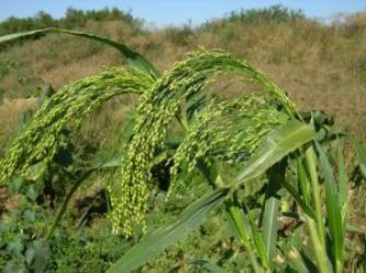
In the Minoan warm period millet was grown in southern Scandinavia.
Not much is known about the Minoan warm period beyond, what can be gauged from cores from boreholes in the ice sheet. That the climate really was warmer then may be
derived from that in the Minoan warm period, which occurred during the bronze age, millet was grown in southern Scandinavia. Today Millet is grown in tropical and subtropical regions, it is an important crop in Asia, Africa and in the southern U.S. The average annual temperature in Mississippi and Alabama is about 10 degrees, which should be compared with today's average annual temperature in Denmark, which is 8 degrees. So maybe the climate in the Minoan warm period, was about 2 degrees warmer than present in southern Scandinavia.
As you may know, Rome is said to have been founded by Romulus and Remus in 753 BC The Roman historian Livy tells us that in the city's early history occurred a few severe winters when there was ice on the Tiber, and the snow stayed for many days. Before the Roman warm period beech trees is said to have been growing in mountains around Rome.
Climate changes have always taken place, it is documented in the Bible.
Jeremiah 18:14 in the Old Testament says: "Does the snow of Lebanon leave the crags of Sirion? Do the mountain waters run dry, the cold flowing streams?" indicating that it was really relatively cool around the Mediterranean when Jeremiah lived around 600 BC. In our days is no eternal snow on the mountains of Lebanon.
|
Left: Sea ice in the Arctic Ocean in present time. It is seen that in modern times there is quite a long way from Iceland to the sea ice at the Greenland coast north of Scoresbysund. Whether Pytheas landed on the Faroe Islands, Iceland and Western Norway, only a day's sailing to the solidified sea means that the sea ice in the summer had a very significantly greater extent than in the present.
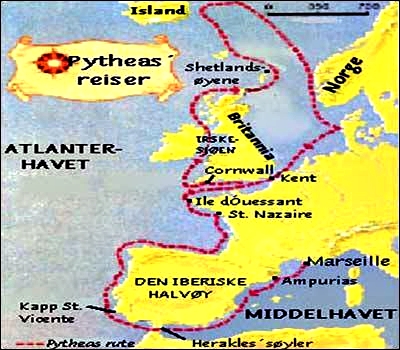
Right: Pytheas' travels - From Histoire des Mares: Pytheas le massaliote.
Around 310-300 BC the Greek explorer Pytheas traveled from Massalia (Marseille) along the shores of Western Europe. He came to Scotland and
Hebrides, where he saw the waves, which were "80 cubits high" (cubit is an ancient unit of length on 45.72 cm). He sailed to the island of Thule, which was located 6 days and 6 nights sailing north of Berrice, which is assumed to be Shetland. There is uncertainty about, whether Pytheas' Thule was the Faroe Islands, Iceland or western Norway.
The distance between Shetland and Faroe Islands is 150 nautical miles, and the distance between Shetland and Iceland is about 380 nautical miles. On the journey to the Faroe Islands, he ,therefore, should have kept a speed of 1 knot, which sounds pretty manageable, also for his time. If Thule was Iceland, he should have kept a speed of 2.6 knots, which does not sound impossible with a good wind.
He describes Thule as an island located six days sailing north of Shetland, near the frozen sea. There is no night at midsummer, he says, indicating that the location must be on the Arctic Circle and that he visited the island in the summer. The frozen sea is one day's sailing north of the island, he says, which also indicates that the island must be Iceland, rather than the Faroe Islands.

|
Left: A statue of
Pytheas in front of the stock exchange in Marseille.
Right: A reconstruction of Pytheas ship. A vessel of this type cannot have navigated the North Atlantic in winter. It emphasizes that he visited Thule in the summertime.
However, in modern times the sea ice nearest Iceland in the summer is found north of Scorebysund on Greenland's east coast. the distance from Iceland to the north of Scoresbysund is more than 350 nautical miles. Pytheas sailed maybe 2.6 knots, so it would have taken him almost 6 days and nights to get to the frozen sea - with the extension of sea ice in modern time.
But as he wrote that the sea ice was only a day's sailing to the north of Thule, we can conclude that the sea ice in the Arctic Ocean in the summer had much bigger extension in his time, 300 BC, than it has today.
Pytheas mentioned that the island was inhabited. People lived on millet and other herbs and on fruits and roots, and where there were cereal and honey, they got their drink from it. The country was rainy and lacked sunshine, he wrote. This leads many to think that he, in fact, landed in Norway. However, if the frozen sea was only one day's sailing away, it indicates only even bigger extension of sea ice.
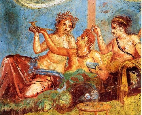
Fresco in Pompeii, depicting a Roman orgy - Casa dei Casti Amanti.
As seen on their light dress it must have been quite hot.
The Roman warm period started quite suddenly around 250 BC and ended about 400 AD. The ancient Greeks and Romans lived in a fairly pleasant climate, which you can also see from the airy robes, in which the antique statues are often dressed.
Some studies in a bog in Penido Vello in Spain have shown that in Roman times it was around 2-2.5 degrees warmer than in the present.
The Roman warm period is amply documented by numerous analyzes of sediments, tree rings, ice cores and pollen - especially from the northern hemisphere.
Studies from China, North America, Venezuela, South Africa, Iceland, Greenland and the Sargasso Sea have all demonstrated the Roman Warm Period. Additionally, it has been documented by ancient authors and historical events.
The Roman Columella wrote in the first century after Christ in "De Re Rustica "(book 1), citing the "reliable author Saserna": "Areas (in Italy), which previously due to the regular severity of the weather could not provide any protection for vine plants or olive trees planted there, now that the former cold have subsided produce olives and wine in the greatest abundance."
|
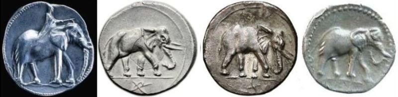
Coins from Carthage with elephant motifs. Note the first coin from the left,
the man is quite large relative to the elephant, which indicates that the elephants really were relatively small.
Hannibal brought a whole army, equipped with 37 war elephants, over the Alps in 218 BC - in winter.
The ancient writer Pausanias wrote in the second century on the use of war elephants: "For although the use of ivory in arts and crafts apparently has been known from ancient times of all men, so no one had seen the actual animals, before the Macedonians invaded into Asia, except the Indians themselves, the Libyans and their neighbors." It sounds like he thinks that elephants naturally belong in both India and Libya.
|
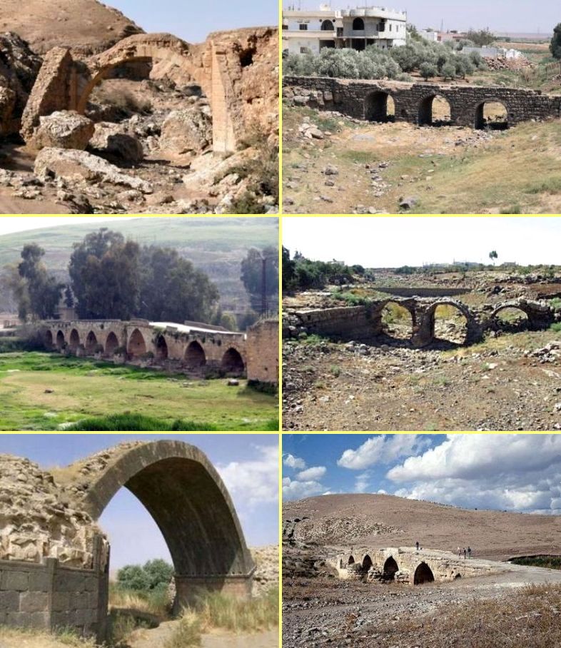
Roman bridges in Syria, Jordan and Iraq. The rivers, which they led over, are
long ago dried up.
Top left: The ruins of a Roman bridge between the villages of Ayyash and
Ain Abu Jima in the northwestern part of the Jebel Bishri by the river Euphrates. - Photo: Minna Lonnqvist.
Top right: Roman bridge in Uthma in Syria - photo: arminhermann.
Middle left: Roman bridge in Maharda in Syria.
Middle right: The Roman bridge Djemarin in Syria.
Bottom left: The Roman bridge Ain Diwar by Malikiyeh in Syria near
the Turkish border.
Bottom right: Roman bridge that spans the Sabun Suyu, which was a
tributary of Afrin in Syria.
It seems unlikely that Hannibal should have imported his 37 war elephants all the way from India to his native Spain. Therefore, most assume that they were African elephants.
The ordinary African steppe elephant is difficult to domesticate, and therefore the animals most likely belonged to a now extinct elephant species
called North African forest elephant that was slightly smaller than both the Indian elephant and the common African steppe elephant.
Around the year 400 AD the Roman Symmachus complained in his letters about the duties, which he had to pay for the bears, which he imported from North Africa to use in the circus game that his son was obliged to give in connection with his entry into the senatorial order. The crocodiles, that he had managed to find, refused to eat, and he was worried that the poor animals should die from starvation before they could play their part in his son's circus game.
Locating vineyards and olive trees is also a good indicator of
climate. During the culmination of the Roman warm period, olive trees grew in the Rhine Valley in Germany. Citrus trees and grapes were cultivated in England as far north as near Hadrian's Wall near Newcastle. Scientists have found olive presses in Sagalassos in the Anatolian highlands of present-day Turkey, which is an
area, where it today is too cold to cultivate olives.
The continued spread of vineyards to the north can be deduced from a decree of Emperor Domitian which prohibits the cultivation of wine in the Empire's western and northern provinces beyond the Alps. The decree was 280 AD revoked by Probus, who allowed the Romans to introduce vineyard in Germany and England.
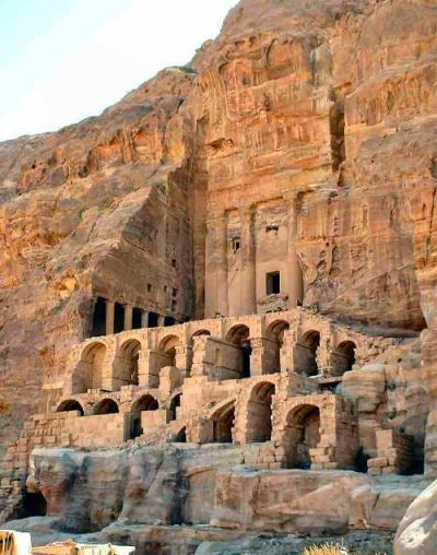
The ruined city of Petra in the Jordanian desert. It was supplied with water from a constructed channel. We must assume that once in the past when the city was built, there was a supply of water on site. As the climate became
drier, they built a channel for water, finally, people gave up and abandoned the city. It is known that in the Crusader period 1100 AC Petra was
still inhabited. King Baldwin 1. of Jerusalem stayed for a while in the
town.
Strabo wrote that around the years 120 to 114 BC a series of storms occurred in the North Sea causing the so-called Cymbrian Flood that covered large areas along the coasts of Denmark and northern Germany with water and thereby caused the Cimbrians and Teutones migration.
North Africa was Rome's granary, which can be difficult to imagine today. But it was much more green and fertile than in the present. The city of Petra in Jordan thrived between 300 BC and 100 CE, today it is abandoned and lies far out in the Jordanian desert.
In the Roman warm period prevailed a more humid climate in North Africa and
the Middle East than today. In Alexandria Claudius Ptolemy wrote a diary of the weather in 120 AD. It shows a remarkable difference from today's climate of this place. It rained every month, except August. There was thunder in all summer months and in some other months, and very hot days were most common in July and August.
Ptolemy of Alexandria also wrote about four rivers in Arabia and trade routes that previously had been used, but already in his time were impassable. In the Middle East ruins of many Roman bridges still exists that are built over rivers, which are now dry.
The Roman Warm Period ended around 350-400 AD.
|
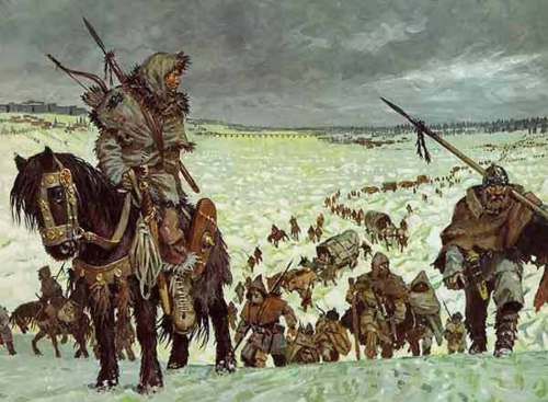
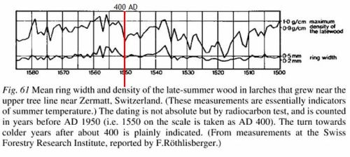
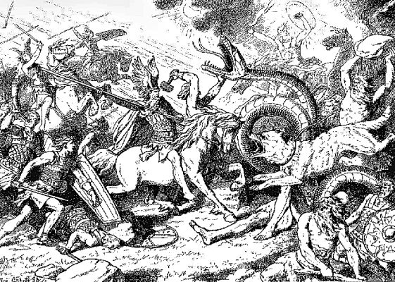
Top: Vandals, Svebes and Alans crossed the frozen Rhine in 406 AD - painting by an unknown artist.
Bottom: Density of growth rings in larch trees at Zermat in the Alps. Time progresses from left to right. The vertical red line marks the year 400 AD - from "Climate History and the Modern World" by H. H. Lamb.
The Vandals crossed the frozen Rhine New Year's Eve 406 AD Kr, thus commencing the Peoples Migration time and heralded the downfall of the Western Roman Empire. The fact that the Rhine was frozen, demonstrates a completely different climate than that, which prevailed when olive trees were growing in the Rhine Valley. I do not recall that the Rhine has been frozen in modern times.
Many believe that widespread drought in central Eurasia triggered the migrations towards both China and the Roman Empire from about 300 AD to 500
AD.
|
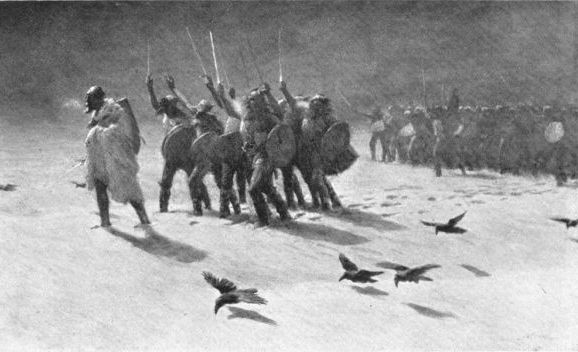
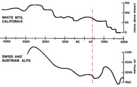
Top: The Scandinavian legend about the Fimbul winter.
Bottom: Changes in the upper tree-line in two areas in the White Mountains of
California and the Alps in Switzerland and Austria. It shows that the tree-line and thus the temperature largely have been declining during at least 3,000 years - The vertical red line marks 400 AD. - from "Climate History and the Modern World" by H.H. Lamb.
H. H. Lamb wrote in his "Climate, History and the Modern World": "For centuries in Roman times from about 150 BC to 300 AD or some few decades later, camel caravans used the Great Silk Road through Asia for trading in luxury goods from China. But from the fourth century AD, which we know from changes in water level in the Caspian Sea and study of irregularities in rivers, lakes and abandoned cities in Sinkiang and Central Asia, drought developed in such an extent that it stopped the traffic on this route. Other severe stages of this drought occurred between 300 AD and 800 AD, and especially around these dates, as it can be seen from old shores lines and old port structures that indicate a very low sea surface level in the Caspian Sea around these times." (page 159).

Chinese cave painting from the Mogave Caves at Dun Huang from the Northern Wei period (386-535 AD) - Some tough men - were they kings?
The drought in Eurasia thus appeared to have had two maxima, at about 300
AD and around 800 AD.
Already around 300 AD, China had problems with refugees from the steppe. "The Five Hu " peoples from the north, Xiong Nu, Xianbei, Di, Qiang and Jie took refuge in the empire behind the great wall. The mandarins ordered them to travel back to their homelands, they answered with force and created
their own migration states. This began the period in Chinese history called "The Sixteen kingdoms".
The drought on the eastern steppe also drove many peoples towards the Roman Empire. From around year 400 AD Visigoths, Ostrogoths, Vandals, Alans,
Svebes, Huns, Gepides, Angles, Saxons, Franks, Jutes, Alemanns, Burgunds and Langobards invaded the empire. Later attacked Avars, Magyars, Arabs, Vikings
and Wends. The political divisions of modern Europe is mainly a result of the showdown among all these peoples.
Ragnarok - In the Scandinavian mythology is told about the Fimbul Winter that will herald the Ragnarok-battle that is the end of the world.
In the first part of Snorri's Edda (55), Gylfaginning, is told: "Then said Ganglere: What tidings are to be told of Ragnarok? Of this, I have never heard before. Har answered: Great things are to be said thereof. First, there is a winter called the Fimbul-winter, when snow drives from all quarters, the frosts are so severe, the winds so sharp and piercing, that there is no joy in the sun. There are three such winters in succession, without any intervening summer. But before these, there are three other winters, during which great wars rage all over the world. Brothers slay each other for the sake of gain, and no one spares his father or mother in that manslaughter and adultery."
In Constantinople the historian Procopius recorded of 536 AD, in his report on the Vandal war: "during this year a most dread portent took place. For the sun gave forth its light without brightness - and it seemed exceedingly like the sun in eclipse, for the beams it shed were not clear. From the moment the phenomenon showed up, humans all time were affected by war, famine and other deadly things." His fellow byzantian Lydus wrote: "The sun became weak - almost a full year - so that the fruits died without harvest."
Michael, the Patriarch of Antioch in Syria (1126-1199 AD), wrote about the year 536 AD: "The sun became dark and the eclipse lasted for 18 months."
The Irish Annals of Ulster recorded: "A shortage of bread in the year 536 AD." The Annals of Inisfallen wrote: "A shortage of bread in the years 536-539 AD". In China was reported from these years that snow fell in August.
Gregory of Tours wrote in "History of the Franks" (Book 3:37) from the years 539 to 594 AD: "In this year the winter was terrible and more rigorous than usual, so that the rivers were kept in the iron grip of the frost and made into a road for the people like it was dry land. Birds, too, were affected by cold and hunger, and were captured by hand without using the snare, when the snow was deep."
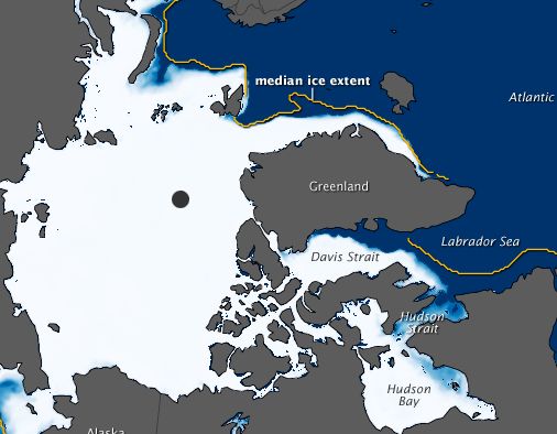
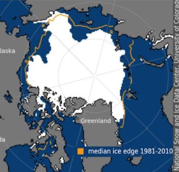
Extent of sea ice in the Arctic Ocean in winter - The yellow line shows the
average spread of ice in January, from 1979 to 2000. The white area represents the distribution in 2011.
This hard winter in the Loire Valley has been dated by Gregory as the year when Theodobert died. This happened 37 years after the death of Clovis, who was king of the Franks in the years 465-511 AD. The Year of the harsh winter is then 548 AD. This suggests that the severe winters in Europe from the year 536 AD may had stretched at least to 548 AD (Most about year 536 AD is from Flemming Rickfors - see link below).
In Jaeren in Norway, large areas were abandoned as farmland around year 500 AD, which indicates a colder and harsher climate. Studies of peat bogs in Jutland show evidence of shifting sand from around the same time. (Lamb)
The Irish monk and geographer Dicuil wrote the book "The Mensura Orbis Terrae" that became known at the Carolingian court in the year 825 AD. He described islands in the ocean that previously were inhabited by hermits, who now, however, have been displaced by Vikings. He provides a description from monks, who had lived in "Thule" until year 765 AD. They had experienced the frozen sea, which was located one day's sailing to the north. They told of Thule that "there was no darkness to prevent any from doing, what they wanted to do". Their description of the sun's path, as well as the temperature, fits perfectly on Iceland.
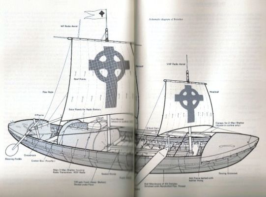
Reconstruction of an Irish curragh from Tim Severin's book "The Brendan Voyage" - To prove that Sct. Brendan really could sail from Ireland via the Faroe Islands, Iceland and Greenland to Labrador, Tim Severin built a curragh and carried out the journey. - It is obvious that such a vessel will not be able to cope with a winter in the North Atlantic. The legend of St. Brendan's journey contains no information on climate.
We must think that he believes "one day sailing" in the summer. It must have been altogether impossible for the Irish monks to navigate the North Atlantic in winter in their small vessels that may have resembled the traditional leather-clad Irish curragh. This indicates that the extent of sea ice has been considerably bigger around 700-800 AD than it is today.
Monastery annals tell of increasing severe winters. Thus the winter 763-64 AD in many places in Europe was described as a winter with a huge snowfall and heavy losses of olive and fig trees in southern Europe.
Also, the winter 858-60 AD was clearly unusual severe. There was ice on the Strait of Dardanelles, and the ice on the Adriatic Sea near Venice was thick enough to support fully loaded wagons.
Also around 860 AD, the Norwegian Floki Vilgerdason navigated the waters around Iceland as the first Scandinavian. When he visited the northern Arnarfjord, he found it packed with ice; which indicates that the climate was considerably colder than nowadays, also in northern countries.
|
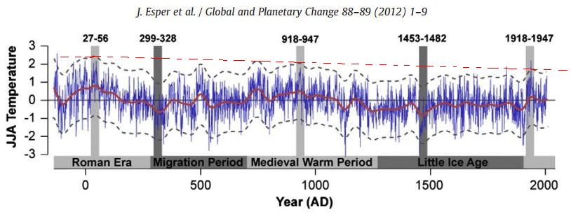
Heat and cold periods through 2000 years compiled on the basis of the density of the growth-rings of pine trees in northern Scandinavia from the period 138 BC to 2006 AD - The blue line is the actual measurements. The red
graph is result of a mathematical smoothing with a 100-year rolling average. The dotted line above and below the red temperature graph is representing uncertainty. The red dotted line at the top shows the general trend, namely that the Middle Ages were warmer than today, and that the Roman era was warmer than the Middle Ages. The vertical gray fields represent selected 30-year periods. The temperature scale to the left shows deviation from a mean temperature over the period 1951-1980. JJA means: June, July, August. Following data from Jan Esper, Ulf Buntgen, Mauri Timonen and David C. Frank "Variability and extremes of northern Scandinavian summer temperatures over the past two millennia." from 2012.
Advanced and accurate measurements of density of the growth rings in Northern Scandinavian pine trees have formed the basis for a highly accurate modern reconstruction of temperatures over the past 2,000 years. It shows that today's warm period is colder than the medieval warming, which again was colder than the Roman era. In modern times, there have been some particularly warm years, such as 2004, but they will be much less visible after a mathematical smoothing. Probably there have always been few years with exceptional heat or cold. It also follows from the historical accounts above about particular severe winters.
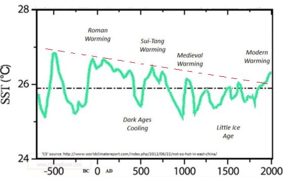
Sea surface temperature in the East China Sea (between Japan, Taiwan and China). It is seen that changes in temperature did not happen simultaneously over the whole Earth. The Roman Warm Period took place also in China, the cold spell of the Peoples migration period was significant, but not very long lasting, instead, it was replaced by the Sui-Tang heating period. The Medieval warm period was not particularly significant in East Asia and nor was the Little Ice Age. But the steadily falling temperature trend has been the same in China as around the Atlantic.
Jan Esper and his co-authors to "Variability and extremes of northern Scandinavian - - " conclude that their results "provide evidence of
considerable warming during the Roman and Medieval warm period in larger scale and of longer duration than the twentieth century heating period." More specifically they identify the Medieval Warm Period to has taken place around 700 to 1300 AD and identify the warmest 30-year intervals during this period, which occurred from 918 to 947 AD in which period the June, July and August temperatures were about 0.3 degrees hotter than the hottest 30-year interval in the current warm period. Their findings differ from other researchers, who think that the Medieval Heating period began around 950 AD.
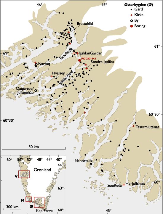
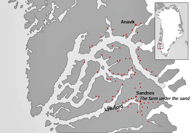
Norse settlements in Greenland. Eastern Settlement, M stands
for Middle Settlement and V stands for western settlement. When the Norse settlements were on its peak, it is estimated from the size and number of farms that there have been between 3,000 and 5,000 Scandinavians in Greenland, which roughly corresponds to the number of inhabitants in Copenhagen at the same time.
In North America, there seems to have been a relatively warm and humid period between 700 AD and 1,200 AD, where maize cultivation spread along Mississippi up to Minnesota. In the waste piles of the past in Iowa archaeologists have found remains of bones of elk and deer, which are woodland animals, but after 1200 AD, they were rather abruptly replaced by bones of bison, which is a steppe animal, indicating a change to a drier climate.
Pollen analyzes from Lake Chad in Africa conducted by J. Maley from the Languedoc University in France shows a maximum of pollen from water-intensive plants in the period 700-1,200 AD, and that the water consuming plants gradually disappeared during the period 1,300 to 1,500 AD (Lamb).
The Medieval warming did not occur simultaneously across the Earth. In East Asia, it was partially replaced by the Sui-Tang heating period that occurred between about 500 and 800 years AD. The medieval warmth was most noticeable around the North Atlantic, but even in Antarctica, it can be traced.
The story of the Scandinavian settlements in Greenland is a good illustration of the Medieval warm period.
In 986 Erik the Red sailed to Greenland with 35 ships. Only 14 ships reached the destination, some sank, and others returned to Iceland. Most of the remaining 14 ships sailed into the fjords to the south around Julianehaab and founded the Eastern Settlement, others sailed a little further north and founded the small Middle Settlement around the present Ivigtut, and some sailed all way up to Godthaab fjord and founded the Western Settlement.
The Greenlanders built farms, houses and churches. There was both a monastery and a nunnery.
In Norse farmers' manure heaps, archaeologists have found big quantities of fish bones from cod. It shows that it generally has been warmer than in the present because, throughout, the 1900s, it has not been possible to fish for cod in Greenland waters; it's been too cold.
The Greenlander Thorkell Farserk was a cousin of Eric the Red. Once when he awaited Erik to visit, he would fetch a sheep that grazed on the island
Hvalsey in Hvalseyjarfjord. Since he accidentally did not have a boat available, he swam out to the island, got hold of sheep and swam back again, that he could entertain his cousin.
|
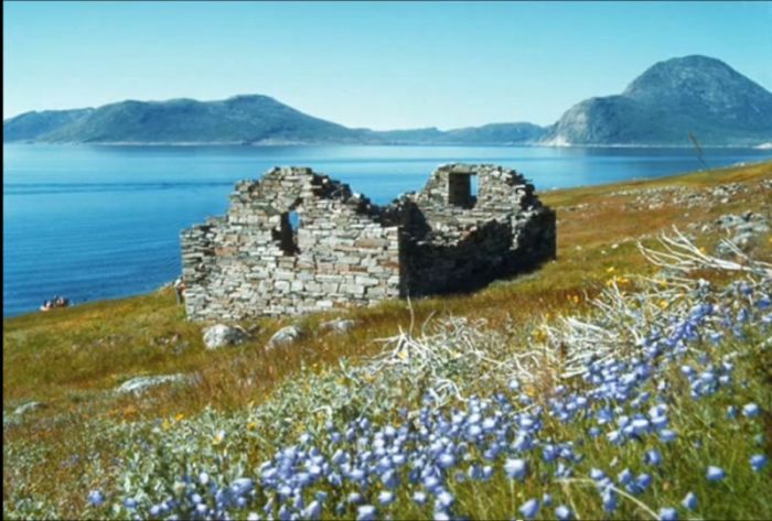
Hvalsey church.
The distance to the island is slightly more than 3.2 kilometers. Dr. Pugh from the Medical Research Laboratories has given his assessment of this achievement to H. H. Lamb. From studies of Channel swimmers' endurance, we know that 10 degrees will be the absolute lowest water temperature, which allowed an experienced swimmer to swim this distance. In modern times, the water temperature in Hvalseyjarfjord usually is in the range of 3-6 degrees in the summer. Therefore, the water at that time must have been at least 4 degrees warmer than today.
In the Norwegian medieval document Kongespejlet (Kings Mirror) from about 1,250 AD is told about the sailing route to Greenland: "As soon as the great ocean has been crossed, there is such an abundance of ice that nothing like this is known from any other place in the whole world, and it is so far from land that there are no less than four or more days to travel to there over the ice, but this ice is more to the North-East and North off the land than from the south-west and West."
This must mean that when you sailed due west from Iceland in the summer, which was the original route, you would meet sea ice along the coast of Greenland. Nowadays there is usually no sea ice as far south in the summer. But maybe they sailed very early in the year.
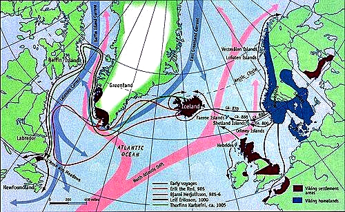
The sailing routes of the Vikings to Iceland, Greenland and America. - From McGovern and Perdikaris, 2000.
About Greenland is further narrated in Kongespejlet: "But since you asked, if the country was free of ice or not, or it was covered with ice like the ocean, then you should know for sure that it is a small part of the country that is free of ice, but all the rest is covered with it, and people do not know, whether the country is large or small, because all mountain areas and also all valleys are hidden by the ice, so that you nowhere find opening on it." - "Few in number is the people in this country because there are few places, which are so ice-free that they are habitable" - "But since you ask about on what people are living in that country, since they do not sow
grain, you must know that there yet exist many other countries, where the people do not sow, and though people are living in them, because humans do not live by bread alone. About Greenland is the saying is that there are good pastures and both good and large farms because they have much cattle and many sheep and produce much butter and cheese. On this the inhabitants have their living since for the most part, also meat and all kinds of hunting prey, both reindeer-, whale-, white bear- and seal-meat, On these things the Greenlanders have their living." - "But since you asked if the sun shines in Greenland, or whether it could ever happen that it was beautiful weather as in other countries, then you must know for sure that there can be beautiful sunshine and that the country most of the time at summertime can be called weather-good."
|
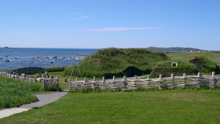
Reconstructed Viking house at L'Anse aux Meadows in Newfoundland" - After
excavation of 2,400 Viking objects, there is no doubt that the Vikings
discovered America long before Columbus.
"But there is a big difference in the movements of the sun because as soon as it becomes winter, it is almost always night, but as soon as it is summer, it is almost all the time day. And when the sun goes highest, it has sufficient force for shine and brightness, but only little to warming and heat; however, it has so much force that where the ground is free of ice, it heats so much that it can provide good and fragrant grass; therefore, people can quite well live in the country, where it is thawed, but that is indeed very little." - "When it is stormy weather it happens with greater rigor there than in most other places, both in terms of the power of the storms and the violence of frost and snow."
But, it seems that the ancient document Kongespejlet was not completely well informed. Danish researchers from the National Museum have found small pieces of charred barley in Greenland Viking middens. The finding proofs that the Norse Greenlanders actually cultivated barley. They were able to produce the important main ingredient that is needed to brew beer.
"If the grain had been imported, it would have been threshed, so when we find parts not threshed, it is a very strong indication that the first Norsemen in Greenland cultivated their own grain", project leader Peter Steen Henriksen said. "One must assume, that if the grain had arrived in Greenland with a ship, it had been threshed first, otherwise it would take up too much space."
|
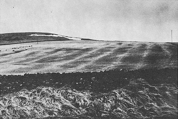
Visible ditches and furrows from medieval fields at Redesdale in Northumberland in England 300-320 meters above sea surface - From H. H. Lamb
"Climate, History and the Modern World"
Another good indicator of climate is the spread of wineyards. When Wilhelm the Conqueror in 1086 AD prepared Doomsday Book, he recorded
Wineries in 46 locations in southern England, from East Anglia to the modern
Somerset. Today there are 400 English wine producers, but it must be seen in
the light of the fact that modern wine-growers have developed wines that are more cold tolerant than the historical varieties. H. H. Lamb concludes that the medieval average summer temperature probably was 0.7 to 1.0 degrees higher than today, and the climate must have been less prone to frost in May.
At the abandoned village Houndtor in 400 meters above sea surface level in the highlands of Dartmoor in the county of Devon in England and at Redesdale in Northumberland near the border with Scotland 300-320 meters above sea surface level still exists visible traces of cultivated fields from the Middle Ages (H. H. Lamb). In this altitude, grain cannot be cultivated in modern times.
In medieval York archaeologists have found the presence of a species of the beetle "heterogaster urtica" that today lives only on nettles in sunny places in Southern England, which also indicates that Middle Ages was warmer than the present (Lamb).
In the Middle Ages two of the Sicilian rivers, Erminio and San Leonardo, were described as navigable, which today is quite impossible even with small
vessels. This shows that precipitation was bigger in the warm climate of the medieval.
|
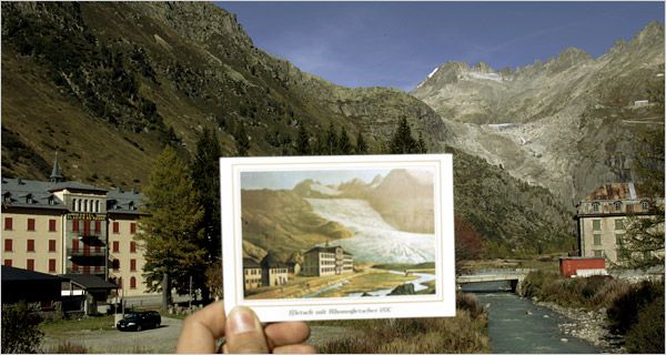
The Rhone Glacier in north-eastern Switzerland on a postcard from 1870
compared to reality in 2006.
The development of this glacier has been very visible, as it can be seen from the nearby small town. During the last 120 years, the glacier has pulled about 1,300 meters back and left a trail of bare stone.
There is no consensus on when the Little Ice Age started and ended, but let
us stick to that the Medieval warming period ended and the Little Ice Age began around the year 1300 AD, as proposed by Jan Esper and his co-authors above. During the Little Ice Age winters were alternately mild and very cold just like today, but generally it was colder - and it became really cold around 1690 AD that may be designated as the culmination of the little ice age. Also around 1660 and 1770 AD winters were extraordinary cold. The winter of 1850 AD was also very cold, but then the temperature rose, and one can say that the Little Ice Age ended and the modern warm period began.
The cold weather came earlier at high latitudes than in southern Europe. In
Greenland and in northern and northeastern parts of Iceland growing of barley was abandoned as early as about 1300 AD, while growing of wine in southern England and Northern France and cultivation of oranges in Provence of southern France were first abandoned about 1500 AD.
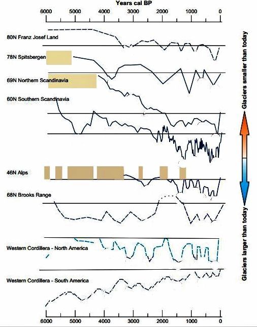
Eight time series of glacier advances and withdrawals through the Holocene
during the last 6000 years. Most are not continuous, because they are based on morphological evidences as moraines, U-shaped glacier valleys etc. The Scandinavian graphs are continuous. To make it easier to compare, they are all presented as graphs. The graphs of the Alps are best supported by growth rings in trees and other documentation for the past 3,500 years. Except for Scandinavia and the Alps the exact times for glacial retreats are not known, and they are shown somewhat arbitrarily. The brown areas show, where the graphs have been concluded from indirect evidence such as residues of trees above the modern tree-line, buried topsoil etc.
When the graph is above the corresponding horizontal line, it indicates the warming and smaller glaciers than today, and when the graph is below the line it indicates cooling, and glaciers bigger than today. Note that the names of the mountains are placed at the start of the graph itself, and not at the connected horizontal line. All graphs end on the corresponding horizontal line, which represents the present.
Sources of information:
Franz Josef Land (An archipelago in the Arctic Ocean): Lubinsky et al., 1999,
Spitsbergen (An island in the Arctic Ocean, also known as Svalbard): Svendsen and
Mangerud (1997) and Humlum et al. (2005).
Northern Scandinavia: Nesje et al. (2005), Bakke et al. (2005), IPCC (2007).
Southern Scandinavia: Matthews et al. (2000,2005), Lie et al. (2004), IPCC (2007).
Alps: Holzhauser et al. (2005),Jo'rin et al. (2006).
Brooks Range (In the northern Alaska): Ellis and Calkin (1984).
Western Cordillera-North America: Koch and Clague (2006).
Western Cordillera-South America: Koch and Clague (2006).
Glaciers of the Northern Hemisphere have typically been smaller in the past, and then they have grown down through the Holocene to a maximum during the Little Ice Age, after which they have pulled back a little.
From: "Mid- to Late Holocene climate change: an overview" by Heinz Wanner, Jurg Beer, Jonathan Butikofer with others.
The Little Ice Age seems to have been most noticeable in Europe and North America; but it could also be felt in China, Alaska, Caucasus and Himalayas; everywhere the glaciers increased. Only South America seems to have been quite unaffected.
Cultivation of heat demanding fruit trees, such as mandarins and oranges had to be abandoned in China's southern Jiangxi province, where these varieties
before had been cultivated for hundreds of years. In the first half of the 1600s, China was plagued by droughts and floods. Unable to pay their taxes to the Ming emperors the peasants made revolt and thus paved the way for the Manchu conquest of China and the subsequent Qing dynasty.
The Western Settlement in the Godthaab fjord in Greenland was abandoned already around 1350 AD in the beginning of the cooling period.
Icelandic sagas tell that 1350 AD the bishop of the Eastern Settlement was
reported that the Western Settlement was in need of assistance to drive away the aggressive Inuits, whom the Norsemen called Skrellings.
The bishop sent a church envoy, Ivar Bardson, to the rescue. But when he arrived to the Western Settlement, he found the country deserted except for a few loose livestock. Taking the Icelandic sagas literally, it was more Skrellings than it was the worsening climate that caused the end of the western settlement. Apparently, the meeting between Inuits and Norsemen did not always process peaceful.
|
The western settlement covered very close to what today is Nuuk (Godthaab) municipality. The red dots indicate farms.
In 1723 the Norwegian explorer and missionary Hans Egede visited Godthaab district, and he asked the Inuits in Ujaragssuit near the ruins of the Western Settlements church, if they had destroyed it. They replied no and told that Qavdlunak (Norsemen) did it themselves, before they departed.
Ivar Bardsson lived in Greenland from 1341 to 1364. He wrote on navigation from Iceland to Greenland: "From Snefelsness in Iceland to Greenland by the shortest route, two days and three nights. To be sailed due west. - In the sea there is a reef called Gunbjornsskaer. It was the old route, but now comes the ice from the north, so close to the reefs that no one can sail the old route without risking his life."
The last certain report we have about the Eastern Settlement is from some Icelandic travelers' account of a wedding in Hvalsey church: "Thousands and four hundred eight years after our Lord Jesus Christ's birth we were present, saw and heard in Hvalsoy in Greenland that Sigrid Bjornsdatter were married with Thorstein Olafson." Thus it is written in the laconically Icelandic sources that tell of Norse life in Greenland. The wedding took place - the first Sunday after Cross Fair - 14. September 1408 AD.
|
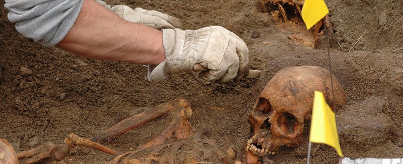
Excavation of Norse grave in Vatnahverfi in Julianehåb district.
In 1492 Pope Alexander VI expressed, however, his anxiety about the situation in Christendom's northern outpost: "The Church in Garda lies at the end of the world in Greenland, and the people, who dwell there, are accustomed to live on dried fish and milk due to the lack of bread, wine and oil - shipping to that country is very irregular because of widespread ice on the water - no ship has called their shores for eighty years, it is believed - or if travel takes place, it is thought, only in August - and it is also said that no bishop or priest has had office in eighty years or so." - "The people of Greenland have been abandoned by the church so long that they have returned to the "pagan practice", wrote the Pope as he offered the Benedictine monk Matthias Knutson the position as bishop of Gardar, if he would be willing to travel there and lead the people back to Christianity.
Carbon-14 analysis from bones taken from Norse cemeteries in Greenland, suggest that the Eastern Settlement existed until about the year 1500 AD.
|
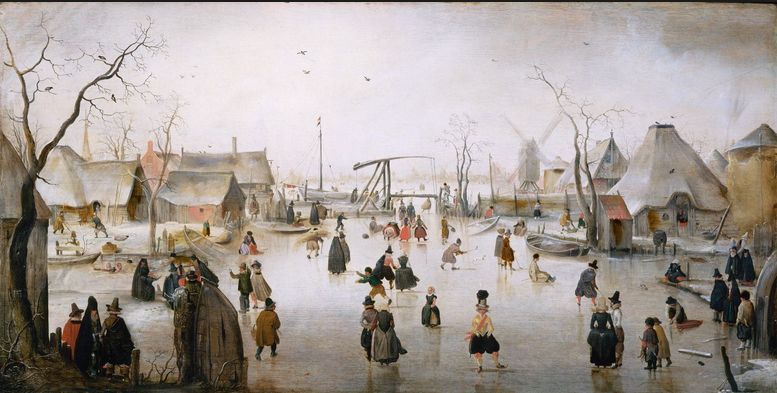
During the "Little Ice Age" in Europe flourished life on frozen canals in the Netherlands. People were skating on the ice and shopped in market stalls, which was established on the ice. It was a popular motif for several painters - Painting by Francis G. Maye.
There are told many Eskimo legends about battles between Norsemen and Inuits. They are about Norsemen, who kill many Inuits, and Inuits, who kill Norsemen. Hans Egede made many trips along the coast in search of the missing Norsemen. When he 1723 came to Julianehaab district, it seemed to him that the Inuits there were "quite beautiful and white" as opposed to those, whom he had previously met. His son Niels Egede was the first to learn the Inuit language. To him the Inuits told that the Norsemen were attacked by pirates, and their women and children fled to the Inuits. When they returned all the Norse houses had been burned down, and the men have been killed. The Inuits then went deeper into the fjord and married the Norse women.
A ship commanded by John "Greenlander" was in 1540 traveling from Hamburg to
Iceland, but was blown off course by a storm. The crew went ashore in Greenland at the Eastern Settlement. They found a settlement that looked like those in Iceland, but the buildings were empty apart from the body of an old man dressed in leather with a cap of cloth lying on the floor in a house with a worn knife in his hand.
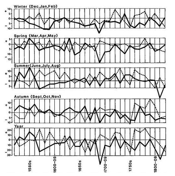
Temperature and humidity near Bern and Zurich in Switzerland as an average for each decade from around 1520 to 1820 AD - The solid line represent temperature and the dotted line represent humidity - It is seen that the Little Ice Age peaked around 1690. In addition, it can be seen that there has been widespread frost in the spring months, March, April, May. Even in the summer months, there has been freezing weather - Prepared by Dr. Christian Pfister from the Geographical Institute at the University of Bern - From "Climate, History and the Modern World" by H. H. Lamb.
When Hans Egede in 1741 after his stay in Greenland lived in Copenhagen, he wrote about a monk of Greenlandic blood: "At a German Autorem named Dithmarum Blefkenium I otherwise found an account about a monk, who was supposed to have been born in Greenland, with the bishop from that same place Anno 1645 (presumably it must be 1545) and should have travelled to Norway and since lived in Iceland l546, where he, according to his report, personally should have spoken to him. This same monk should have told strange and curious things about a Dominican Monastery in Greenland called Sct. Thomas Monastery, into which he in his childhood had been submitted by his parents with the intention that he there should become monk."
Also another source, which Hans Egede mentions, talks about this monk. That
is a Danish sea captain named Jacob Hall, who had also met the Greenlandic monk and described him as follows: "He had a wide face, and his color was brown".
Around 1623-25 AD Bjorn Jonsson from Skardsa in Iceland reported that he
had found pieces of wreckage on the beach, which were typical for ships built in Greenland.
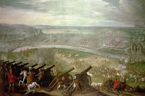
In 1529 a huge Turkish army under Sultan Suleyman had to withdraw from a siege of Vienna due to poor military results, cold rain and heavy snow as early as October.
|
The Turkish siege of Vienna in 1529 - Due to cold rain and heavy snow
already in October the Turks had to withdraw from a siege of Vienna in the
middle of the month. They lost many soldiers and equipment during the retreat to Constantinople through snow and mud.
According to a weather diary from Zurich from the period 1546-1576 AD the
frequency of snowfall increased 44% in the first part of the period until 1563, and increased further by 63% in the last part to the year 1576 AD (Lamb).
Tycho Brahe's observations in Denmark from 1582 to 1597 indicate a
winter temperature, that was 1.5 degree below the average temperature of the period 1880 to 1930 AD. Furthermore, Tycho Brahe's observations tell that wind from the east was dominant. In his notes southeast was the most frequent wind direction (Lamb).
A priest in eastern Iceland named Olafur Einarsson wrote in the early 1600s a poem that illustrates the Icelanders' problems:
Formerly the earth produced all sorts
of fruit, plants and roots.
But now almost nothing grows -
Then the floods, the lakes and the blue waves
Brought abundant fish.
But now hardly one can be seen.
The misery increases more.
The same applies to other goods -
Frost and cold torment people
The good years are rare.
If everything should be put in a verse
Only a few take care of the miserables -
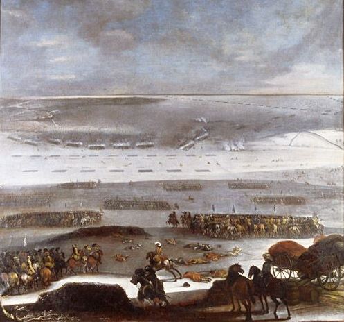
The Battle of Tybrind Vig on 30. January 1658. The Swedish king Karl 10. Gustav marched over the ice on the strait of Lille Belt with 10,000 men at night and caught the Danes completely by surprise. Painting by Johan Philip Lemke.
In winter of 1657-1658 war broke out between Denmark-Norway and Sweden. By this time the Swedish King led war in Poland. The winter proved to be unusually cold, and all the Danish waters became completely covered by ice. By the announcement of the Danish declaration of war, the Swedish King Carl Gustav lost any interest in Poland and turned immediately against Denmark. He led his ten thousand men with horses and a few cannons over the ice from island to island, and soon they showed up in front of the walls of Copenhagen. At the same time, the Danes were unable to use their fleet because of the ice. Denmark-Norway was completely unprepared for this development, and King Frederik 3 asked for negotiations. At the Peace of Roskilde, Denmark-Norway had to submit Scania, Blekinge, Bornholm and the Norwegian provinces Bohuslen and Trondheim Province.
Around 1580 AD, the Denmark Strait between Greenland and Iceland in several summers was completely blocked by pack ice. In the winter of 1695 AD Iceland was completely surrounded by sea ice.
Already about 1615 AD, the Faroe cod fishing began to fail, and through the thirty years under the Little Ice Age climax 1675-1704 AD, there were absolutely no cod in Faroe waters. A recent Danish study has shown that cod can thrive in many different temperatures, but they seem to prefer temperatures between 1 and 8 degrees when they breed. Maybe water temperatures in the North Atlantic were too low. Through most of modern time, it has not been possible to fish for cod in the waters around
Greenland, probably for the same reason.
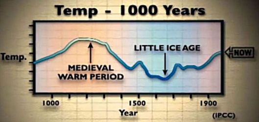
The Medieval warming and the Little Ice Age. - From the BBC documentary: "The Great Global Warming Swindle".
In Norway new small glaciers formed in the mountains of Hardanger during the maximum of the Little Ice Age. Between 1690 and 1710 AD there were numerous cases in Norway about farms that were destroyed by advancing glaciers. Thus the Nigard glacier advanced 3 km between 1710 and 1743 AD and destroyed thereby a farm named Nigard. The owner sent a letter to King Frederick 5, in which he asked for compensation for the destruction.
Also in North America, the winters were very cold and long. The inhabitants of the small English colony of Jamestown, which had been founded in 1607 on the coast of Virginia in the current U.S., complained about unusual long and cold winters. Quebec's founder Samuel Champlain noted that in June in the year 1608 AD there was ice that could bear at the shores of Lake Superior.
There is no consensus on when the Little Ice Age ended, and the Modern
Warming Period began, but I will stick to around 1850 AD, as proposed
by Jan Esper, Ulf Bontgen with others above.
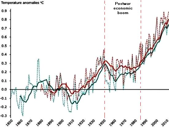
The global temperature in the modern warm period - The red dotted line is results from GISS, which is Goddard Institute for Space Studies at NASA. The dotted green line are the results from the UK Met Office Hadley Centre compiled by the Climatic Research Unit from the University of East Anglia. The solid red line is the results from the Goddard Institute for Space Studies at NASA's results, which are mathematically smoothed with a 10-year rolling average. The solid green line is the results from the UK Met Office Hadley Centre, which are mathematically smoothed with a 10-year rolling
average. The horizontal 0.0 line represents the average of temperatures from the period 1850 - 1899 (UK Met Office Hadley Centre) and 1880-1899 (NASA GISS). - The graph is from the European Environment Agency. The upward trend of the solid lines since 1998 must have been caused by some mathematical subtleties, as the temperature did not increase since 1998, which is also shown by the dotted lines.
Since 1850, the Earth's average global temperature has increased by around 0.8 degrees compared to the average of the period between 1850 and 1899. Europe has warmed 1.2 degrees, which is more than the global average.
It started cold. In January and February 1864 AD, when the Danish soldiers waited behind the ancient defence-dike Dannevirke on the Prussian and Austrian armies, both the wide marshes of western Schleswig, that should protect their right flank, and the fjord Slien, that should protect their left flank, was completely frozen, and precisely therefore, they made an organized retreat to the Dybboel redoubts to avoid encirclement. It also seems that it has been pretty cold in the trenches of Flanders during the first World War.
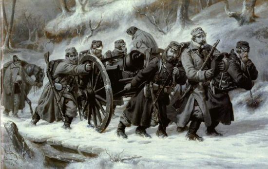
|
Top: Painting by Nils Simonsen "Episode of the retreat from Dannevirke
on 5 - 6. February 1864 "painted in 1864.
Bottom: Two young women from Malmo in front of the frozen Oresund in 1924.
There was occasionally ice on the Thames. In 1924 the inner Danish waters were completely frozen, and one could walk from Scania to Copenhagen.
Some of the older generations of Danes can probably remember that their family in the countryside had a sleigh standing in a dusty corner of the barn. At the beginning of the twentieth century it was as a matter of course that there was snow in winter, and when you wanted to go somewhere, you simply harnessed the horses for the sleigh. Perhaps they were used for the last time during the severe winters in the 1940's.
|
Boise city in Oklahoma USA was 15. April 1935 hit by a giant dust storm that blew the upper topsoil layer of the fields. This great disaster that struck the American Midwest, is called "the Dust Bowl".
At the end of the 1800's the Western Prairie was the last land in North America that became cultivated. The settlers had a few good years, and then the problems began with locusts and drought. The "Dust Bowl" of the 1930's was caused by degraded soil and years without rain, entire fields took off to the air in big black dust storms that could blow for days. "There was dust everywhere. It came into the houses, in the food and between the teeth" a settler told. Hundreds of thousands of people loaded the few possessions, they had and fled to California - as in Steinbeck's "The Grapes of Wrath".
Also in China, very large areas of newly reclaimed land in the provinces of Shaanxi and Inner Mongolia were reduced to desert in the first half of the 1900's.
From 1915 and throughout the interwar period the temperature increased, and by the end of the Second World War, the average temperature has risen about one and a half degrees since 1850. This warming period started before automobiles, airplanes and other CO2 emitting vehicles were invented at all, and the man-made CO2 emission was negligible.
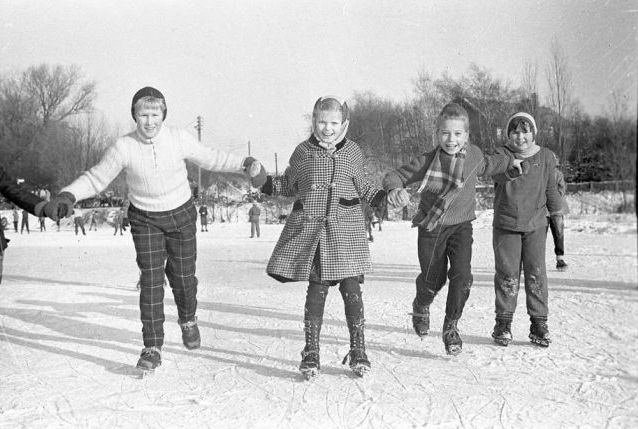
|
Top: Ice winter in 1956 at Dalum near Odense - Denmark.
Bottom: Emissions of CO2 from fossil sources from the year 1800 to 2000 AD. - from
Wikipedia.
During the industrial boom in 1950-1980 the industry bloomed as never before, it supplied cars, refrigerators, airplanes and all kinds of consumer goods. The most of anthropogenic CO2 has been emitted precisely in this
period. Supporters of the theory of anthropogenic global warming believe that CO2 emissions have made the global temperature to go up. But nevertheless, in the period, where the industrial boom took place, the temperature dropped over four decades and Northern Europe and North America experienced again winters with lots of snow.
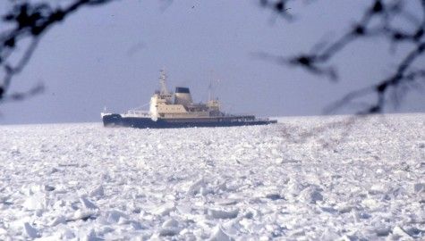
Icebreaker in Store Bælt of Denmark in the winter 1981-82 - Foto Ove Hesstrup Hansen.
The Ice winter of 1981-82 was the coldest that ever has been measured in
Denmark. The winter already started at 7. December and 17. December was measured minus 25.6 degrees Celsius in Jutland - during the daytime.
First, during the economic crisis in the late eighties temperature again began to rise.
One-third of all human CO2 emissions have taken place since 1998. However, the global temperatures have not increased in that same period.
The theory of anthropogenic greenhouse gases that cause global warming assumes that the long-wave heat radiation from the heated earth surface becomes blocked by CO2, which acts as the glass in a greenhouse, and thereby prevents heat to radiate back into space.
The long-wave outgoing heat radiation from the greenhouse interior is stopped by the glass, which converts the energy of the radiation into heat in the glass.
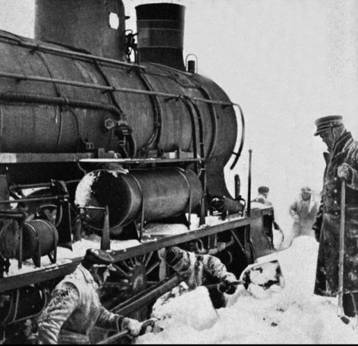
|
Top: A locomotive is dug free of snow on the Roskilde railway - Denmark - in winter 1942.
Bottom: Ice packs on the Øresund at Charlottenlund near Copenhagen in the winter of 1987.
Therefore, scientists suppose that if the theory of anthropogenic global warming because of the greenhouse effect is true, then we should be able to measure a warming in the atmosphere - in the same way that the long wave-length outgoing heat radiation deliver its energy as heat to the glass in the greenhouse, thus the long-wave outgoing heat radiation from the Earth surface and the clouds should deliver some of its energy as heat to the atmosphere, since it is here, it will be stopped by CO2, it is said. Scientists have figured out that most heat should be found in an altitude of about 10 km. But whether they measure with weather balloons or satellites, there can be detected no warming in this altitude. On the contrary, it is clear that the heating takes place at the surface of the Earth and not in the atmosphere - suggesting that the idea of man-made global warming due to CO2 emissions is not true.
It is true that both atmospheric CO2 and global temperature has increased in the modern warming period; But the warming does not match the theory, it has occurred the wrong place at the wrong times.

The sun as it looked like on 8. June 2013 - from spaceweather.com - For a very long time no sunspots had appeared and experts had begun to fear of a new Little Ice Age. But now, finally, some small spots showed up.
On the Sun one can see some dark spots which are called sunspots. They are typical of the size of Earth, which means between 4,000 and 50,000 kilometers in diameter. The spots are about 1,000 degrees Celsius cooler than the rest of the sun's surface, which is approx. 5,750 degrees. Contrary to what one might believe, the sun radiates most energy when there are many sunspots, because simultaneously with the spots warmer areas occur around them, which more than compensate for the lower temperature of the spots.
Sunspots were first described by the Greek philosopher Teofrastos from Lesbos in 300 BC. He saw some strange black spots on the sun's surface. There are also earlier reports from China, which tell us that sunspots have been seen with the naked eye; it is sometimes possible - with caution when the sun is low in the sky and blurred by haze. Galileo directed his telescope towards the sun in 1613, observed, described sunspots systematic and issued a "Letter on sun-spots".
Some sunspots grow very large lasting several months, others become only a few hundred square kilometers big and disappear within a few days. Since the mid-1800's we have known that the number of sunspots varies with a period of 11 years so that every 11 years there will occur maximum sunspots.
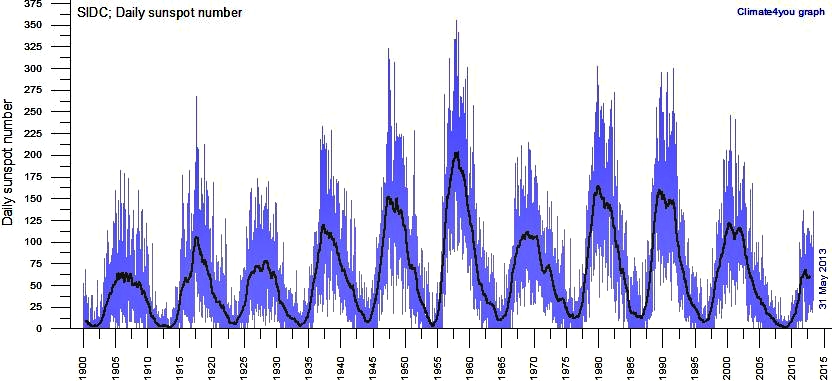
|
The daily number of sunspots since 1900 from the Solar Influences Data Analysis
Centre (SIDC). Note the 11-year cycle. We are just now in 2013 about maximum sunspot activity of period of 24, which run from around 2009 to around 2020. Maximum sunspot activity should occur about 2014-15, but the number of daily sunspots is never the less still quite low.
Systematic counts of sunspots have been routine since Galilei invented the telescope. During the Little Ice Age the astronomer Cassini from Paris reported in 1671 that he had found a sunspot, and it was the first one that he had seen in many years. The Englishman Edward Maunder studied ancient records on sunspots, and came to the conclusion that during the Little Ice Age there were virtually no sun-spots. The period was named the Maunder minimum.
It is such that, when there are many sunspots, the solar magnetic field will be strong and deflect much cosmic radiation directed toward the Earth. When there are no or only a few sunspots, the Sun's magnetic field will be weak allowing more cosmic radiation to hit the Earth.
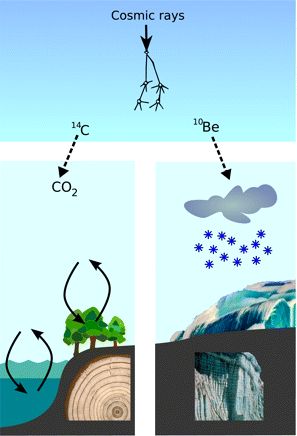
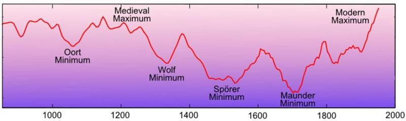
|
Top: Carbon-14 and Beryllium-10 are created when cosmic rays enter the atmosphere.
Bottom: Solar activity through 1.000 years as revealed by carbon-14 analysis. Oort minimum refers to a minor cold period in the Medieval heating period, note also that Wolf and Spurs minimum occurred in the Little Ice Age. The graph ends around all-time maximum in 1950. The activity has since then decreased significantly.
When cosmic rays hit Earth's atmosphere new isotopes are generated, especially carbon-14 and beryllium-10. When the cosmic radiation is strong, there will be formed many of these isotopes, and when the cosmic radiation is weak, there will not be formed as many. Both carbon-14 and beryllium-10 are unstable isotopes that decay over a very long time.
By analyzing historical records, carbon-14 content of trees growth rings and beryllium-10 content in ice cores from the ice caps, scientists have been able to reconstruct past levels of cosmic radiation and identify other periods, when the Sun's activity and its magnetic field has been weak, such as the Oort Minimum, Wolf Minimum, Sporer Minimum and of course Maunders Minimum.
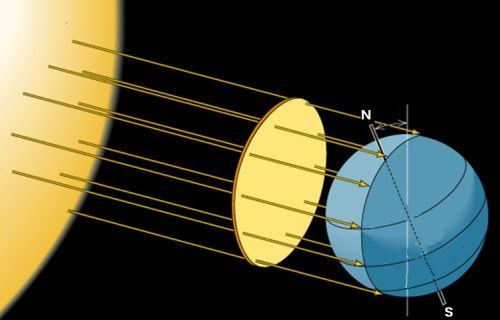
The radiation from the sun has an intensity of 1,370 W/m2 on an imaginary surface perpendicular to the line between the Sun and Earth located above the atmosphere at the equator.
There is a correlation between the number of sun-spots and the intensity of the solar radiation that reaches Earth. When there are many sunspots the suns radiation will be stronger. Currently, the radiation from the sun has a strength of 1,370 W/m2 on an imaginary surface perpendicular to the line between the Sun and Earth located above the atmosphere at the equator. Solar irradiance on this surface oscillates with an amplitude of 1.2 W/m2 between the maximum and minimum number of sunspots. That is only 0.09% of the total radiation - It will not at all be noticeable!
But, however, there are very powerful amplification mechanisms.
The sun has a magnetic field which is several thousand times stronger than Earth's. Currently, the Sun field is about 2,000 gauss, which should be compared to Earth's field that is 1 gauss. It stretches far into space, entirely out beyond Pluto's orbit. Since 1990, the solar magnetic field has decreased from 2,700 gauss to the current about 2,000 gauss. Sunspots are regions on the Sun with intense magnetic activity. Many sunspots are a sign that the solar magnetic field is strong and few sunspots mean that the field is less strong.
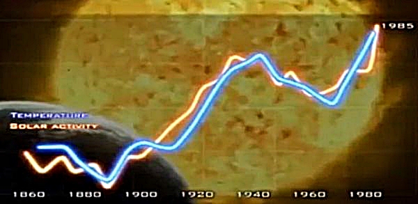
|
Eigil Friis-Christensen and Henrik Svensmark found a very close correlation
between Sun's magnetic activity and Earth's temperature - From the
documentary "The Cloud Mystery".
The sun is a star in the Milky Way Galaxy, which contains at least 100
billion other stars. Some stars explode as super novaes thereby emitting particles, may be electrons, protons, neutrons, or ionized atomic nuclei, which enter Earth's atmosphere - sometimes with near the speed of light. Earth and the solar system are thus constantly exposed to cosmic radiation.
But only some of the cosmic rays hit the Earth; a big part is deflected by the Sun's strong magnetic field. When there are many sunspots, and the Sun's
magnetic field is strong, it will deflect much radiation and the cosmic
radiation, which enters the atmosphere will be weak. But a lazy sun with few
or no sunspots will have a weaker magnetic field and deflect a smaller part of the cosmic radiation. The radiation, which enters the atmosphere, will, therefore, be more intense.
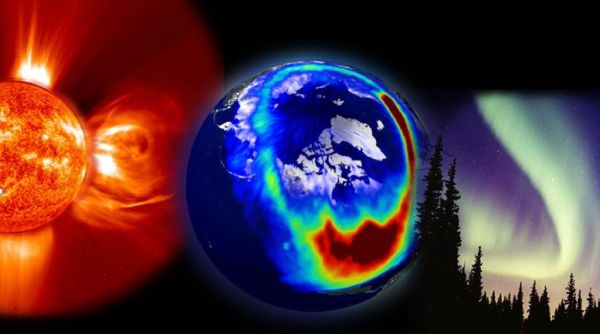
|
The Sun's has a very strong magnetic field, which extends all the way to the orbit of Pluto and beyond. It should be noted that northern lights are created by particles emitted from Sun, which meet Earth's magnetic field. It is not created directly by the Solar magnetic field.
The Danish scientists Eigil Friis-Christensen and Henrik Svensmark have demonstrated that clouds are created by cosmic radiation. This means that when the cosmic radiation, that enters the atmosphere, is strong, the Earth's cloud cover will be extensive, and when the cosmic radiation is weak, Earth's cloud cover will be less extensive.
We imagine generally that clouds are composed of water vapor. It is not
the case since water vapor is a transparent gas. Clouds consist of aerosols, which are clumps of molecules of different kinds, mainly water molecules.
Aerosols are formed around a particle or ion.
When a cosmic particle enters Earth's atmosphere with tremendous speed, it
beats the electrons lose from all the molecules that it hits on its way
thereby creating a trail of ions that quickly find together creating aerosols in an atmosphere containing water vapor, the aerosols will then create clouds.
When cosmic radiation particles enter Earth's atmosphere with great energy, they create ions and thus aerosols, which accumulate into clouds. (Photo from NASA)
During the last 100 years, until the beginning of the new millennium, the Sun's magnetic field has doubled. Precisely for this reason, the cosmic radiation that hits Earth dropped by about 15%. This caused that there are now fewer low clouds over the Earth. Low clouds have a cooling effect, and as there have been fewer of them, we probably have here the explanation of the Modern Warm Period. Today Earth's average cloud cover is about 60% - 70%. Small changes in cloud cover bring about changes in climate.
We have often on our own bodies learned that cloud cover has a marked cooling effect. We are lying on the sand at the beach after a swim, bathed in sunshine. Then a cloud passes the sun, and immediately we feel the heat disappear.
During the Little Ice Age, about 1700 AD was a period of practically no sunspots at all. We can, therefore, assume that the solar magnetic field was weak and therefore allowed a great deal of the cosmic rays to enter the Earth's atmosphere. The cosmic rays caused clouds to form to fairly large extent. This extensive cloud cover reflected the sun's rays from their white upper side preventing the sun to heat the Earth, and therefore the Little Ice Age was such a cold period.
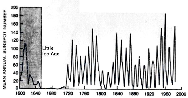
|
Average annual number of sunspots since 1600 from "Climate, History and the
Modern World" by H. H. Lamb.
Eigil Friis-Christensen and Henrik Svensmark's theory, that variations in the solar magnetic field are the cause of climate change, challenges the prevailing theory that man-made CO2 is causing global warming.
Christensen and Svensmark's theory is based on simple assumptions and simple
experiments, which can be confirmed by experience of our daily lives; such as that when a cloud passes the sun, you will feel that it gets colder. The fog chamber is a simple device, which has been known since C.T.R. Wilson in 1927 won the Nobel Prize for the invention.
The theory of anthropogenic CO2 as the cause of global warming is far more subtle and speculative, and it requires to a greater extent that common people
blindly believe experts.
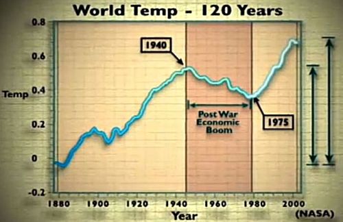
|
Top: Earth's temperature since 1880. It can be seen that during the industrial expansion in the postwar period, when most CO2 were emitted, the temperature dropped down to the 1980's ice winters. First with the economic crisis of the eighties it again began to rise - From the documentary "The Great Global Warming Swindle".
Bottom: Traces from trajectories of elementary particles in a Wilson cloud chamber.
The content of CO2 in the atmosphere is today 385 ppm (parts per million), which is 0.0385 %, that is close to four ten thousand parts. It is really not readily obvious that a marginal change in such a small volume can change the climate significantly.
The enormous popular support for the theory of anthropogenic CO2 emissions as the cause of climate change is by all accounts due to that the theory is in tune with our Judeo-Christian culture's idea that we are all sinners.
Furthermore, the accusation against the industrial companies, that they are the main culprits of emissions, suits well with the feminist's attack against the white men and the socialist concept of the evil capitalists.
|
Drivtømmer og strandvolde afslører 10.000 års variationer i havisen Jens Ramskov i Ingeniøren. Historic variations in Sea Levels Part 1- from the Holocene to Romans (pdf). Late Pleistocene and Holocene climate of SE Australia reconstructed from dust and river loads deposited offshore the River Murray Mouth Franz Gingele, Patrick De Deckker og Marc Norman (pdf). Drivtømmer fundet på Nordgrønland - Youtube Interview med Svend Funder lektor ved Grundforskningscenteret for Geogenetik. Roman Warming (was it global?) JoNova Tackling tribal groupthink. Klimaskifte - Fimbulvetr - den store vinter år 536 e. Kr. Verasir - Som altid behandler Flemming Rickfors emnet meget grundigt. Om Grønland, dets natur og klimatiske forhold - et uddrag fra kongespejlet. Oversat fra Islandsk og med forord af Chr. Dorph (pdf). Vikingerne dyrkede korn på Grønland. af Sybille Hildebrandt - Videnskab.dk. What Water Temperatures Can Cod Handle? The Fish Site. Global and European temperature (CSI 012/CLIM 001) - Assessment published May 2011 by European Environment Agency. Svensmark: The Cloud Mystery youtube Dokumentar af Lars Oxfeldt Mortensen. - 52 minutter. Solpletterne forsvinder om få år, spår amerikanske forskere Jens Ramskov - Ingeniøren. Solarmonitor.org Here you can follow the development of sunspots Holocene climatic and environmental changes in the arid and semi-arid areas of China: a review Z. D. Feng, C. B. An og H. B. Wang. To The Horror Of Global Warming Alarmists, Global Cooling Is Here af Peter Ferrara i Forbes. Fra Grønland til Nyaland - Asernes Æt. Earth's Climate History (Kindle Edition) by Anton Uriarte. Climate, History and the Modern World (Kindle Edition) by H. H. Lamb.  Syun-Ichi Akasofu's model of interglacials as result of heat pulses.
Everything is relative, Syun-Ichi Akasofu of the International Arctic Research Center, University of Alaska Fairbanks seems to think. Most believe that the current average global temperature of 14-15 degrees is normal, and ice ages are abnormal. Syun-Ichi believe that the ordinary normal average temperature on our planet is a glacial temperature of about 5 degrees and the 15 degrees occurs only in short periodic heating periods, which happens every approx. 100,000 years. The heat always comes quickly and then disappears returning the climate down to the normal 5 degrees. Syun-Ichi does not mention, but with such a view, you can almost only think that the periodic heat pulses come from the Sun. The Big Ice Age or The Big Steamy Age? Syun-Ichi Akasofu International Arctic Research Center, University of Alaska Fairbanks (The page is unfortunately not active any more). Muller and MacDonald suggest that the recurring glaciations and interglacials are due to that Earth at regular intervals moves through regions of space with cosmic dust, which is assumed to reduce the solar radiation that Earth receives. One can visualize the alterative astronomical cycle that Muller and MacDonald have found, which suits the climatic records. Imagine a flat disc with the sun in the middle and the nine planets that orbit around it close to the disc. In fact, all the planets orbit close to such an imaginary disc. It is believed that this imaginary disc space contains more cosmic dust than the rest of the space. At regular intervals Earth's orbit tilts slowly out of the level of the imaginary disc, heat up because of the more clean space, then returns again. When Muller the first time calculated the cycle of Earth's orbit deviation from the Solar System's imaginary disc level in 1993, he found that it repeated every 100,000 years. Astronomical Theory Offers New Explanation For Ice Age Berkeley Lab - Research News by Jeffery Kahn. July 11, 1997 - explanation of Muller and MacDonald's theory. |
| To start |